Hey there, DC! I’ve been away on holiday for a few weeks, out in the Philippines where a December “chill” means temperatures dip below 80°F and where we spent New Year’s Eve scuba diving, but since I got back I’ve been looking forward to some snow, and the weather today has not disappointed.
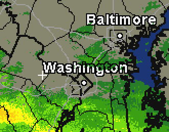 If you’ve been obsessively watching the precipitation approach on radar like I have, you might have noticed that for a moment, as the snow began to wash over the DC area, an expanse of non-snow persisted over the District itself for a few minutes before the flakes began falling downtown. That’s likely an Urban Heat Island effect in action; the city’s greater propensity for heat-trapping and heat-generation affecting the local impact of passing weather systems. Urban heat has been implicated in increased summer thunderstorm activity, but in the case of today’s snow, it means that we get less accumulation here downtown, as more of it tends to melt as it falls or after hitting the ground.
A strong enough system can still beat the Heat Island effect and turn DC into a winter wonderland; so to today’s snow clouds I say, try harder. Bring it on.
This post appeared in its original form at DC Metblogs