Dupont Circle, The Features, Where We Live

Where We Live: Dupont Circle

Photo courtesy of
‘a hug on Riggs’
courtesy of ‘NCinDC’

Welcome to Where We Live: Dupont! Dupont Circle is one of the District’s best-known neighborhoods, and there’s so much history and beautiful architecture to love here.  Dupont is home to everyone from recent grads in group houses to young professionals in condos to well-off diplomats with kids, and yes, even some new stars.  I know I’m probably supposed to be unbiased in my descriptions of all these neighborhoods, but to be honest, Dupont’s my favorite.  Read on to find out why.

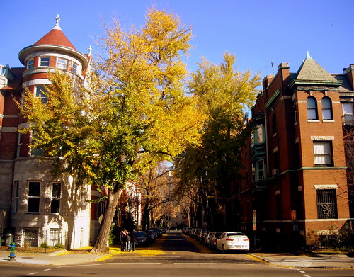
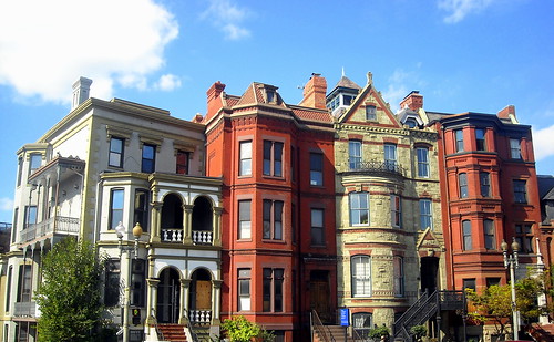
History: Not much was really going on in the Dupont area until the Civil War.  Up until then it was a rural backwater, but a massive modernization program built streets and sewers in the 1870s, making the area a fashionable new residential district.  In 1871, the circle itself (then known as Pacific Circle) was constructed, and in 1882 Congress decided to use the circle to honor Civil War admiral Samuel Francis Du Pont.  A statue of Du Pont was erected in 1884, and replaced in 1921 with the fountain that we all know and love today.  The traffic signals in the circle were added in 1948 to make it easier for pedestrians to cross, and in 1949 the Connecticut Avenue tunnel was built to separate thru traffic and build a streetcar station.

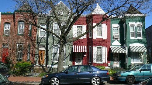
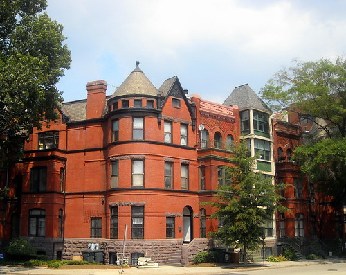
By the 1870s and 1880s, impressive mansions were built along Massachusetts Avenue, and Connecticut Avenue had more shops and offices.  Much of the area was developed with rowhouses, many of which remain today.  The neighborhood began to decline after the 1968 riots, but in the 1970s some urban pioneersmoved in.  Dupont Circle took on more of a Bohemian character, and the area became a gay enclave.   It is considered the historic center of the gay communityin DC, though many of those original urban pioneers later moved on to Logan Circle or Shaw.  The 1980s and 1990s saw more reinvestment in the neighborhood, and today Dupont Circle is again one of DC’s most desired neighborhoods.

Continue reading

Life in the Capital, The District, The Features, Where We Live

Where We Live: Mount Pleasant

Photo courtesy of
‘Shrine of the Sacred Heart’
courtesy of ‘NCinDC’

The diverse and eclectic Mount Pleasant neighborhood is the topic of this week’s Where We Live.  It was once a streetcar suburb and is now a mix of housing types  with a main street of its own.  It has great access to downtown and is right in between Adams Morgan and Columbia Heights, two very developed areas, but it has retained a quieter residential character.  Read on to hear the very cool history of Mount Pleasant and what to check out next time you’re there.

History: The neighborhood dates back to 1727, when a large area of what is now Columbia Heights/Adams Morgan/Mount Pleasant was granted to James Holmead.  The area was named Pleasant Plains in 1750, and then became part of the District when it was established in 1791.  During the Civil War, the area was home to a hospital, and after the war the neighborhood became known as Mount Pleasant Village.  The area was separated from the rest of the District by rural land, as DC hadn’t grown into its 10-mile square yet, which is why Mount Pleasant doesn’t quite line up with DC’s orderly grid of streets.  In the 1870s, the area became the District’s first streetcar suburb, and many middle class residents moved in to take advantage of the quick commute to Washington City.

The area has changed a lot since then.  In the 1950s, the neighborhood became racially segregated, with many white residents leaving the city altogether.  The 1968 riots only made things worse, and the area entered a period of decline.  However, throughout the 1960s Spanish-speaking immigrants began moving to Mount Pleasant, establishing vibrant communities of El Salvadorean and Dominican Republic immigrants.  In the 1980s and 1990s, affluent professionals began moving into the area for its access to jobs downtown and its historic residential housing stock.  And today, the population is a mix of all those eras: approximately one third of residents are white, one third are African-American, and one third are Hispanic.

Neighborhood Character: Mount Pleasant has a strong historic residential character throughout the neighborhood and a pedestrian-friendly commercial strip along Mount Pleasant Street.  Rowhouses and smaller apartment buildings make up the neighborhood, and many historic structures from the early 1900s remain.  The area is very walkable, with strong transit access and a variety of neighborhood destinations.  In recent years, Mount Pleasant has been changing due to the nearby development of Columbia Heights.  Tim, author of the neighborhood blog The 42 and Mount Pleasant resident of six years, had this to say:  ” There obviously have been hundreds of changes, some from within and many from without.  We’ve been greatly affected by the development of Columbia Heights.  Most of that has probably been good for Mount Pleasant in terms of access to amenities.  On the other hand, we’ve seen stagnant development of out own commercial strip at the same time.”

Continue reading

Life in the Capital, Special Events, The District, The Features, Where We Live, WMATA

Where We Live: Southwest Waterfront

Photo courtesy of
‘The Forgotten City’
courtesy of ‘M.V. Jantzen’
Hello and welcome to another edition of Where We Live.  This week we’ll be checking out the smallest quadrant in the District, Southwest.  Can you imagine city planners essentially wiping out an entire neighborhood and starting from scratch?  Well, that’s what planners did to this area back in the 1950s.  Read on to hear how it happened, and what’s going on today in one of the most overlooked neighborhoods in the city.

History: The southwest quadrant was present in Pierre L’Enfant’s original plan for the city in 1791.  In 1793, the city’s first rowhouses were built at Wheat Row, and in 1796 the Thomas Law House was built for one of DC’s first investors (both structures remain to this day).  In 1815, the Washington City Canal was built and essentially cut off this part of the city from the rest of the District.  The area became home to many poorer residents and tenements, but the neighborhood was thriving with churches, synagogues, and shops.  Anthony Bowen made this area a stop on the Underground Railroad.

But by the 1950’s, planners working with Congress decided that the Southwest Waterfront area was the place to try out all these novel urban renewal concepts, so they declare eminent domain over virtually all of SW, wipe out nearly all of the houses and shops and churches in the area, and cause the displacement of nearly 30,000 people.  Planners then build a series of modernist residential and office buildings, cut through the area with freeways, and destroy nearly all urban character that was there to begin with.  The neighborhood businesses were replaced by various new buildings and the Waterside Mall (which was recently demolished), which included a Safeway and satellite EPA offices.  These businesses didn’t exactly create a vibrant urban neighborhood, so they’ve been torn down to create a clean slate for massive new redevelopment.

Continue reading

Essential DC, History, Life in the Capital, The District, The Features, Where We Live

Where We Live: Capitol Hill

Photo courtesy of
‘The Shape of Colors in DC’
courtesy of ‘Gen Jones (Gen-esis Photography)’

This week we’ll be looking at the Capitol Hill neighborhood. This neighborhood could probably be called the largest in DC, since essentially anything east of the Capitol, north/west of the Anacostia River, and south of Union Station is generally known as Capitol Hill.  The area is home to so many great places, from Eastern Market to Barracks Row to Union Station, and it also has some of the best historic architecture in the city.

History: The hill that the Capitol sits on was originally called Jenkins Hill (or was it?).  Pierre L’Enfant decided that it would be a good location for the “Congress House”, and before you knew it, it became the center of residential development in our fair city.  Because it was so close to the Capitol, congressmen lived in Capitol Hill boarding houses, and because it was so close to the Navy Yard, it was also home to craftsmen and laborers.  The neighborhood continued to grow throughout the nineteenth century, and many historic rowhouses in the area date from this era.  It was mostly a mixed-income neighborhood for the nineteenth and early twentieth centuries.  However, the fringes of Capitol Hill were hit hard by drugs in the 1980s, and as recently as 2000 crime was out of control in Hill East (if you get a chance, check out Jim Myers’ description of that time in The Atlantic).  Most of the area has bounced back, and Capitol Hill is now the city’s largest historic district and one of the city’s greatest neighborhoods.

Neighborhood Character:  The neighborhood is certainly one of the District’s most diverse.  You’ve got empty-nesters, long-time residents, recent college grads, families with small children, and Hill staffers all mixed together in a few square miles.  Hill East resident Shaun says, “My fiance and I live in a condo that’s home to Georgetown law students, Hill staffers and a retired woman who’s lived at our intersection for so long, she remembers when the new condo around the corner was a crack house.” Historic rowhouses make up the majority of the housing in the area, with a few apartment buildings and condominiums throughout the area.  Commercial development is mostly located along Pennsylvania Avenue, 8th Street SE (Barracks Row), and around Metro stations.  The area is quite pleasant to walk around, with brick sidewalks and mature trees and beautiful views of the Capitol.

Continue reading

Essential DC, Foggy Bottom, Life in the Capital, The District, The Features, Where We Live

Where We Live: West End

Photo courtesy of
‘Schneider Triangle’
courtesy of ‘NCinDC’

Welcome to another installation of Where We Live. This time we’re focusing on the area between Dupont and Georgetown. Some call it Foggy Bottom, others call it GW, but the neighborhood most recently has been calling itself West End.  Read on to hear why this area is among the city’s oldest, but also one of the most rapidly changing, neighborhoods.

History: The area is known as West End because it literally was the west end of Pierre L’Enfant’s original plan for Washington.  It was also known as Foggy Bottom because of the marshy, humid conditions and the concentration of smoke-emitting businesses in the area along the waterfront (so really, it’s more like Smoggy Bottom).  The rowhouses in the neighborhood housed these industrial workers, so the area was home to many Irish and German immigrants back in the 1850s, along with their breweries.

Then the area started changing rapidly.  Columbian College (what we now know as George Washington University) was established near Meridian Hill in 1821, moved to the Foggy Bottom area in 1912, and expanded significantly in the 1920s and 1930s.  The decline of river-oriented industries led to the closing of many waterfront employers, and the area lost a lot of ethnic diversity as industrial workers left the neighborhood.   By the mid-twentieth century, rowhouses were being torn down in favor of high-density apartment buildings, and much of the character of the neighborhood was lost.  We can thank the Foggy Bottom Restoration Association and the DC Restoration Office for preserving the rowhouses that still exist in the area today.  (If you’re interested in more history of the neighborhood, check out this PDF brochure put out by the DC Office of Planning.)

Continue reading

Downtown, Essential DC, Life in the Capital, The District, The Features, Where We Live

Where We Live: Logan Circle

Photo courtesy of
‘Logan rowhomes’
courtesy of ‘NCinDC’

This week: Logan Circle! With a great mix of housing and retail, good connections to the city’s transportation network, and proximity to downtown, Logan Circle is one of DC’s most sought-after neighborhoods. What makes it so great? Well…

History: Logan Circle was part of Pierre L’Enfant’s original plan for DC, and was called Iowa Circle until 1930, when Congress renamed it to honor Civil War hero John Logan. After the Civil War, the area became home to DC’s wealthy and powerful, and by the turn of the century it was home to many black leaders, including Mary McLeod Bethune. Logan Circle, along with nearby Shaw, became the epicenter of Black Washington in the early- to mid-1900s. Continue reading

The District, The Features, Where We Live

Where We Live: Brookland

Photo courtesy of
‘snowy, icy, icky’
courtesy of ‘wageslaves’

Welcome to the first installment of a new feature on We Love DC! Every two weeks, we’ll introduce you to a different neighborhood in the city. This week: Brookland! Located in Northeast, Brookland is full of small-town charm with the amenities of being in the middle of a big city.  It’s walkable, full of history, and rich in community character.

History: The neighborhood gets its name from the 1840 Brooks Mansion, home of Colonel Jehiel Brooks (a veteran of the War of 1812).  In the 1870s, the B&O Railroad opened Brooks Station adjacent to the Brooks Estate, which provided commuter rail service to Downtown DC and Silver Spring.  In 1888, the city’s first electric streetcar line opened, and the area grew quickly.  Brookland developed as a streetcar suburb, and in 1889 the Catholic University of America opened on a 70-acre tract of land near the station.   In the mid twentieth century, religious groups were encouraged to buy property in the area to support the university, and thus the area became known as “Little Rome” with a high concentration of Catholic institutions. Continue reading