Talkin' Transit, The Daily Feed

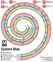
Metro Board authorizes new Station Names for map

Photo courtesy of
‘DC Metro Spiral (Names)’
courtesy of ‘thisisbossi’

The Metro board today met to consider some station names and changes to be made ahead of the next redesign of the map and authorized a number of changes to stations you may know and love. Here’s the skinny, straight from Metro:

  • Navy Yard becomes Navy Yard-Ballpark.
  • King Street becomes King St-Old Town.
  • Waterfront-SEU will drop SEU, because the university no longer exists.
  • Forest Glen will be shown on the map with the universal “H” symbol to indicate the location of Holy Cross Hospital.
  • Foggy Bottom and Medical Center will also be shown with “H” symbols reflecting proximity of hospitals.
  • New York Ave-Florida Ave-Gallaudet U will be renamed “NoMa-Gallaudet U.” “New York Ave” will be shown as a secondary name for one-year to assist customers during the transition.

Four stations were unaltered, due to public familiarity with their names, despite their length:

  • Grosvenor-Strathmore
  • Georgia Ave-Petworth
  • Franconia-Springfield
  • Ronald Reagan Washington National Airport

The new names will take effect next year when the June 2012 Metro Map hits the streets.  The cost to rename the stations is estimated to be approximately $400,000, though no formal figure is available.

Alexandria, The Daily Feed

Lovebirds and Ducks Agree: Alexandria Waterfront is Filthy as Homemade Sin

Love Note

I found this note on a dock at Alexandria’s waterfront area the other day while my Lovely Wife and I were taking what could have been a lovely stroll. Of course, the jerk who was so upset about pollution as to write this note also was dumb enough to make more litter by leaving it there.

The river is polluted and dirty, littered with bottles, tires, bags, shoes and even dead fish. Yes, apparently it’s even too dirty there for the fish. On our 20-minute walk, I counted no fewer than five fish floating in the filth. That’s pretty messed up.

Take a look at one view of the trash:
Continue reading

Life in the Capital, Special Events, The District, The Features, Where We Live, WMATA

Where We Live: Southwest Waterfront

Photo courtesy of
‘The Forgotten City’
courtesy of ‘M.V. Jantzen’
Hello and welcome to another edition of Where We Live.  This week we’ll be checking out the smallest quadrant in the District, Southwest.  Can you imagine city planners essentially wiping out an entire neighborhood and starting from scratch?  Well, that’s what planners did to this area back in the 1950s.  Read on to hear how it happened, and what’s going on today in one of the most overlooked neighborhoods in the city.

History: The southwest quadrant was present in Pierre L’Enfant’s original plan for the city in 1791.  In 1793, the city’s first rowhouses were built at Wheat Row, and in 1796 the Thomas Law House was built for one of DC’s first investors (both structures remain to this day).  In 1815, the Washington City Canal was built and essentially cut off this part of the city from the rest of the District.  The area became home to many poorer residents and tenements, but the neighborhood was thriving with churches, synagogues, and shops.  Anthony Bowen made this area a stop on the Underground Railroad.

But by the 1950’s, planners working with Congress decided that the Southwest Waterfront area was the place to try out all these novel urban renewal concepts, so they declare eminent domain over virtually all of SW, wipe out nearly all of the houses and shops and churches in the area, and cause the displacement of nearly 30,000 people.  Planners then build a series of modernist residential and office buildings, cut through the area with freeways, and destroy nearly all urban character that was there to begin with.  The neighborhood businesses were replaced by various new buildings and the Waterside Mall (which was recently demolished), which included a Safeway and satellite EPA offices.  These businesses didn’t exactly create a vibrant urban neighborhood, so they’ve been torn down to create a clean slate for massive new redevelopment.

Continue reading

Monumental, The Features

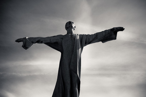
Monumental: Titanic Memorial

Photo courtesy of
‘Titanic~esque’
courtesy of ‘spiggycat’

In 1931, Helen Herron Taft, the widow of President Taft, unveiled the grey granite statue overlooking the Potomac just about where the Kennedy Center stands today. The statue now stands down on the Washington Channel near Fort Lesley McNair in Southwest. Just to the south of the Waterfront became the home for the Titanic Memorial.

The Memorial is dedicated to the men aboard the Titanic who gave their spots in lifeboats to women and children and perished in the shipwreck in the North Atlantic. Scribed at the bottom is the dedication, the kind of thing you wouldn’t see on a modern monument, from the “Women of America.”

The monument itself is pretty well hidden down in Southwest, and I ended up driving past it a couple times, and getting lost more than once. Park at the roundabout near the Harbor Police Office on Water Street, and there’s a footpath to the south of the roundabout. Take it down two blocks past O Street down to the memorial. Looks like a great place to ride your bike down to. With the weather today being off-the-charts-for-Awesome, and better expected for the Weekend, take a bike on out to the Monument’s location in Southwest. It’s worth a trip.