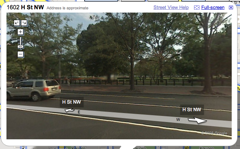
Many thanks to Rob Pegararo of the Post for tweeting about the appearance of Street View for Google Maps here in DC, finally, after long last. This shot, taken on H St NW just north of the White House, is an example of Street View. What’s so utterly cool about it, though, is that the image is draggable, like moving the orientation of the camera. So you get a sweet panorama of your neighborhood.
I looked at my place, and saw both our cars, and the photos looked fairly recent, taken in Fall at any rate. I’ve seen some shots of Clarendon after a snow, and some other spots in different seasons. Spot anything cool? Let us know in the comments.
I live and work in the District of Columbia. I write at We Love DC, a blog I helped start, I work at Technolutionary, a company I helped start, and I’m happy doing both. I enjoy watching baseball, cooking, and gardening. I grow a mean pepper, keep a clean scorebook, and wash the dishes when I’m done. Read Why I Love DC.


This is too funny – of all the people, my ass is on Google Street View!
By what I was doing, that photo was taken in summer of 2007.
brilliant! judging from the construction near us, our street view was taken a month or so ago… and wow, wayan. wow.
CONGRATS TO WAYAN’S CELEBRITY ASS
Darn. We live in one oddly not mapped neighborhood – we’re surrounded by blue lines … but none for us.
A time warp! Go to 1402 Irving St. NW, then click East once – a 4 month jump in one click. Pretty awesome to see the before and after at DCUSA like that.