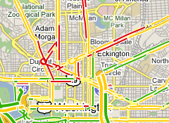
I went to go look at Google Maps to plot a route this afternoon, when I saw something that I’d not noticed before: Google Maps’ Traffic data now covers more than just the usual interstate and highway routes, it also covers some of the center-of-town major thoroughfares that you might be traveling on as you head through town. Dupont Circle, 16th St, Connecticut Ave, Independence and Constitution Ave are among those covered, but it also looks like Suitland Parkway, Route 1, Pennsylvania Ave, Route 7, and others are included in the makeover. How sweet is that?!
I live and work in the District of Columbia. I write at We Love DC, a blog I helped start, I work at Technolutionary, a company I helped start, and I’m happy doing both. I enjoy watching baseball, cooking, and gardening. I grow a mean pepper, keep a clean scorebook, and wash the dishes when I’m done. Read Why I Love DC.


Where do they get this ? Only Lake county Illinois has sensors!
I would guess it was cellphone information, David, but I’m not sure. I’ll write them and try to find out.
Thanks Tom Google can be cryptic
I was going to ask one of our GIS experts
Phones were my guess . I know there are some bugs because US 52 going into Mendota Illinois showed RED all afternoon US 52 there has 1000 cars a day . With cell phone it might be red becasue that car may have stopped
Incredible…you’re the first one to pick this up. They got the whole western Suburbs of Chicago up…