
‘Takoma 1791 Boundary Stone’
courtesy of ‘Mr. T in DC’
Welcome to another week’s DC Mythbusting. This week we’ll talk about a myth I heard when I first moved to DC– that the city’s boundaries are marked off, every mile or so, with stones. I heard that these stones had been placed long ago when Andrew Ellicott and Benjamin Banneker were surveying the city, and that they’re mostly still there. I’d never seen them or heard of them outside of that once, so I assumed it was a myth. But I was wrong– this myth is confirmed!
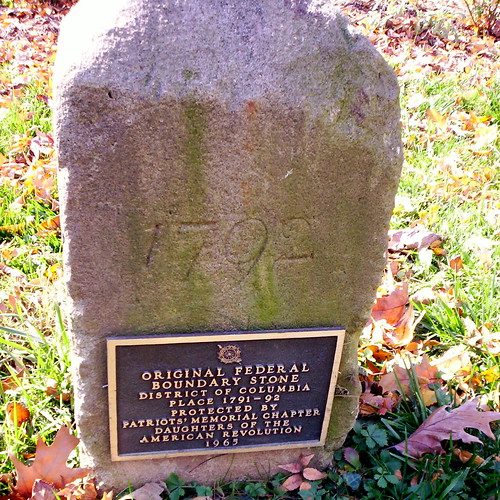
Back in 1791 and 1792, Andrew Ellicott and friends went around the 10-mile square of the planned City of Washington and placed a boundary stone every mile. The stones had four sides– facing inward towards DC (which read “Jurisdiction of the United States” and a mile number, facing outward (which showed the name of the bordering state, either Maryland or Virginia), and the other sides showed the year the stone was placed and the compass variance at that point.
‘DC Northwest Boundary Stone 7’
courtesy of ‘zhurnaly’
In 1915, the Daughters of the American Revolution volunteered to maintain the stones, and they installed gates around each of them for protection. However, by the mid-1900s several stones had been displaced by construction projects. Today, the Nation’s Capitol Boundary Stones Committee seeks to preserve the stones. The stones are made of sandstone, which is soft and not durable, which has caused the damage and cracks. The committee is studying the best way to preserve the stones on a case-by-case basis.
Interestingly, the stones are the oldest federal monuments in the country, and they are listed on the National Register of Historic Places. Many of the forty stones remain in their original places, including the ones that now mark the boundary of Arlington County, Virginia. Due to the development in the area, the stones now stand in such places as a church parking lot, a road’s median, and at the bottom of a pipe at Blue Plains Impoundment Lot. Because of development pressures, many of the stones have been moved to more convenient locations– check out this map of actual vs. theoretical locations.
The stones have received some press from the Washington Post’s John Kelly recently, and boundarystones.org is a fantastic resource for information on the stones. You probably pass them by without even knowing they’re there, so find directions to your nearest boundary stone and go check it out!
The boundary stones map is awesome. Love the living history stuff you do.
Thanks!
The one closest to me, in S. Jefferson St. in Arlington (well, border of Arlington and Fairfax counties) is only listed as a theoretical one on the map you link you. It’s definitely there!
Also, minor mistake: the stones did not originally mark the boundaries of the City of Washington, it was the District of Columbia. The City of Washington, when it existed, was roughly what’s within Rock Creek, Florida Avenue, the Anacostia and the Potomac.
Wonder what they used for the center of the diamond?
Pingback: DCBlogs » DC Blogs Noted
Wow, I knew there was one by my house in Arlington, but I had no idea they went all around the DC Square… Very cool.
@Jay: It’s within the Organization of American States building http://maps.google.com/maps?ll=38.893085,-77.040773&spn=0.01,0.01&t=h&q=38.893085,-77.040773
In general, though, the border of the district has very little to do with other landmarks in the district such as the street system, the main buildings, etc. L’Enfant planned the city, while Ellicott’s 1791 and 1792 work was about the district. As I said above, the city was a pretty small part of the district (or territory, as it was at the time).
Thanks Tim. What I meant was what did Ellicott and Banneker use as the center point when they were laying out the stones?
The surveyors didn’t need a center point. They started at the southernmost point and went around as they delimited the 10-mile square.
Check out this link as well:
http://www.washingtonpost.com/wp-dyn/content/article/2009/05/13/AR2009051303585.html
And of course, mythbusters was not even needed if this site was visited:
http://www.boundarystones.org
Pingback: The Search for Boundary Stones – Part I | brunch and the city