”
courtesy of ‘Chris Rief aka Spodie Odie’
(Hopefully you read that title to the theme song of the popular 80’s cartoon)
UPDATE: NWS just issued a Winter Storm Warning with up to 20″ of snowfall.
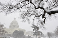
Unless you’ve been hiding for a few days, you know that our beloved city is in for a real winter storm this weekend. And by that I mean REAL. A once every three years or so kind of thing for DC with predictions of over a full foot of snow even inside the beltway. But what makes this storm even more unusual than simply the amount of snow that could fall is the fact that we could experience the meteorlogical phenomenon that is thundersnow. DUN DUN DUN. A thunderstorm with snow? What? Crazy talk? Luckily, we have Logan Johnson, a Senior Meteorologist with the National Weather Service, here to save the day.
“Thundersnow is a rare weather phenomenon, which is basically a thunderstorm that forms in weather that is cold enough for the precipitation to fall in the form of snow instead of rain. Thundersnow is rare because normally thunderstorms need warm and moist air to form. Cold and drier air, like what occurs during the wintertime, is not very conducive to the development of thunderstorms. The two things that are necessary for thundersnow are the presence of unstable air and a force that will push this unstable air upwards. This force of rising air is provided by strong low pressure. The low pressure will push the unstable air upwards, allow for clouds and thunderstorms to form, and provided that the atmosphere is cold enough, it is thundersnow,” writes Logan. His full detailed and exclusive forecast just for WeLoveDC, including a complete explanation, is after the jump.
Logan also says that the latest NWS forecasts show that DC could get hit with anywhere from 8″ to 14″ of snow. You can pick your TV/radio station or internet site of choice to get your predictions, but they pretty much all originate from what the NWS issues anyway. So here you have it, straight from the source. The updated forecast, which will be out in a few hours, may actually revise these snowfall numbers up even further.
“You couldn’t design a more perfect snowstorm for DC. It’s absolutely textbook perfect. It’s gonna be perfect.”
Now, stay home this weekend and enjoy what could be a very rare and downright cool winter storm.
Logan’s full exclusive WeLoveDC forecast and explanation:
Thundersnow is a rare weather phenomenon, which is basically a thunderstorm that forms in weather that is cold enough for the precipitation to fall in the form of snow instead of rain. Thundersnow is rare because normally thunderstorms need warm and moist air to form. Cold and drier air, like what occurs during the wintertime, is not very conducive to the development of thunderstorms. The two things that are necessary for thundersnow are the presence of unstable air and a force that will push this unstable air upwards. This force of rising air is provided by strong low pressure. The low pressure will push the unstable air upwards, allow for clouds and thunderstorms to form, and provided that the atmosphere is cold enough, it is thundersnow.For the upcoming storm, the main reason why thundersnow will be possible is going to be the nearby presence of a very strong and intensifying low pressure system. The storm is currently developing across the Gulf of Mexico and will be taking a turn up the east coast later today. As the low lifts north, it will be intensifying rapidly, and this will act as the force to push the air up and form thundersnow. The low will also be bringing moisture up from the Gulf of Mexico and this will be why heavy snow is expected, because of all the moisture the storm contains.
The National Weather Service forecast for the Washington, D.C. area is for snow to begin late tonight, with the first flakes arriving between 1 and 4 AM. Because it has been cold recently, the snow should have no problem sticking to all surfaces, roads included. Washingtonians will be greeted by a snowy sunrise on Saturday, with several inches already on the ground from DC to the south. Snow will continue throughout the day, falling heavily at times. Winds will increase to 15-25 mph with some higher gusts and this will blow the snow around and create some issues with blowing and drifting. Snow will taper to flurries.after midnight Saturday night.
The current forecast for DC is for 8 to 14 inches of snow, with locally higher amounts possible. However, new computer models are currently coming in, and meteorologists are analyzing and diagnosing this new information, and will be issuing a new forecast this afternoon which will reflect the newest information available.
WOOHOOOOOOO! I can’t wait!
Just have to say, I love your headline for the story! Feel the magic, hear the roar. Thundersnow is loose….
Snarf.
Can’t wait!! Great information!
Best headline ever.
Panthro was the man!
Thundersnow is freaking cool- we had it a few times back home during big storms. Not sure how easy it would be to photograph the lightning, but worth a try- it would be a very unique shot!
Drive carefully folks!
Looks like my flight home won’t be working out! BUT I LOVE BEING SNOWED IN!
Pingback: Don’t get struck by lightning while sledding, but… » We Love DC
Karl – caught your thundersnow bulletin on OJ. I figured Logan would be involved here somehow. Thanks for the informative weather info Johnson brothers! Hope you’re doing fantastic.
Pingback: Snow Details, Snow Fun » We Love DC
With Quantico you never know. It might just be the artillery guys in the field doing some practice ;-)) JK…
Pingback: Got Snow? » We Love DC
Pingback: Weekend Flashback: 2/26 — 2/28/2010 » We Love DC