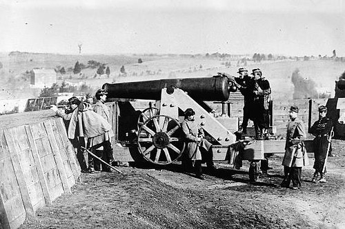
‘Fort Gaines at Tenleytown 1864’
courtesy of ‘NCinDC’
Some of the myths about the city seem a little far-fetched, particularly the more historic ones about the layout of the city. Traffic circles meant to confuse invading armies? No J Street because Pierre L’Enfant held a grudge? Come on. Here’s another one I heard– there’s a system of forts on the outskirts of the District designed to protect the city from an invasion. This story, like the other two, has to be a myth, right? The only fort in the city I can think of is Fort Totten, which (as far as I know) is a Metro station and not some Civil War encampment, and I certainly can’t picture an entire ring of forts around the city. So this myth is pretty easily busted, right?
Not quite. It turns out to be true– there was an incredibly extensive network of forts that once surrounded the city, and today, many of these forts are again being linked together to create a greenway trail for recreational uses. The Fort Circle Park system was a surprise to me, and digging through the history of these parks turned up some other interesting facts.
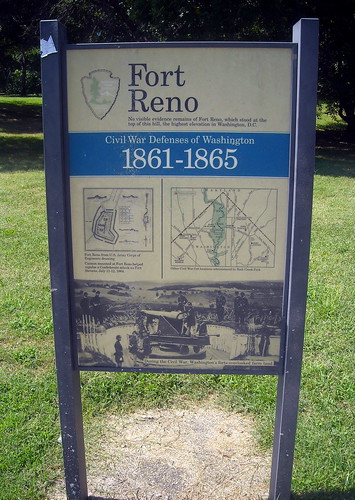
‘Fort Reno’
courtesy of ‘NCinDC’
The Civil War Defenses of Washington were a complex system of fortifications built by the Union to protect the District. With a Confederate state to the south and a Union state to the north, DC seemed like a place that needed some enhanced military protection, so the Union army worked to create 68 forts (mostly on high ground) and 32 miles of military roads in the city between 1860 and 1865. As the National Park Service tells it, “The defenseless city of 1860 had become one of the most heavily fortified cities of the world.”
After the Civil War, the city was left with these huge expanses of open space, often with earthworks and other notable characteristics. Unfortunately, these spaces fell into disuse and many of the fortifications were eventually destroyed. Many of the connecting greenways between the forts were also sold off for development. But in 1902, the McMillan Commission recognized their importance and their potential for recreation, and called for their preservation. The road to preservation has been a bumpy one, as ward boundaries have frustrated attempts to unify the system of parks and trails.

Forts of the Fort Circle System, shown using DC GIS data
As you can see in the above image, some forts remain today (Reno, Dupont, Totten, etc) while others have been lost. Some parts of the greenways remain (check out the northeast boundary of DC between Fort Totten and Anacostia– that’s almost a continuous section there), and some are even used for recreational purposes, like the link between Fort Mahan, Fort Chaplin, and Fort Dupont. The National Park Service is in charge of this land and they’re currently working with the National Capital Planning Commission and the District of Columbia to make these parks more accessible and visible to the public through the CapitalSpace initiative.
Other interesting/fun facts about the Fort Circle Park system:
- Ever wondered why Military Road doesn’t conform to the alphabetical/numerical/state naming system? Well, it was created during this era to connect many of the installations.
- President Lincoln was watching the Battle of Fort Stevens in July 1864 and came under fire from Confederate sharpshooters, but the battle ended when confederate forces realized they couldn’t take the city and retreated to Maryland.
- Hundreds of Confederate troops were killed during the Battle of Fort Stevens, and 59 were killed in the Union side. Battleground National Cemetery was built to bury Union forces after the battle, and today you can visit and listen to this handy podcast to take a tour.
- The Civil War Defenses of Washington were an important site in African American history. The United States Colored Troops were attached to several of the fortifications throughout DC. After the war, some of the forts (like Fort Reno) became a “Freetown” for freed slaves.
- Some of the forts are used today as community centers. Fort Dupont in SE has community gardens, a summer concert series, and the only public indoor ice-skating rink in the city. Fort Reno has a great summer concert series as well.
I’ve got to admit, this was one of the most surprising and interesting Mythbusting features I’ve ever researched. I had no idea that DC was home to such an extensive network of defenses during the Civil War, and I definitely didn’t know that some are still connected by trails. Once it warms up, I can’t wait to head out on my bike and explore some more of the District’s history. Myth confirmed!
And don’t forget the other part of the ring out here in what was then Alexandria County: http://www.arlingtonhistoricalsociety.org/learn/sites_properties/military_use.html
Excellent write up Shannon.
A fabulous book on the subject is Mr. Lincoln’s Forts by Cooling and Owen. A new edition was published last year. I bought it at Fort Ward in Alexandria.
There were four near the Huntington Metro station that comprised the southern most part of the circle. Fort Lyon was just west of the station and was visited by President Lincoln after an accident there in 1863 killed about 21 soldiers.
Yeah, there are many remnants of these fortifications in Arlington, some are now parks, some just appear in the landscape. The group of trees in the middle of the field in this google image Here is growing on top of what was a berm protecting artillery that guarded Chain Bridge.
Thanks for the heads up– I’ll definitely be heading out to check out the Arlington sections as well! I would have loved to map those forts alongside DC’s, but Arlington County doesn’t make its GIS data as publicly available as DC does.
It’s really amazing that many of these fortifications have been lost, and are now surrounded by housing developments or Metro stations or parking lots. I really hope that NCPC’s work to restore them as recreational trails is successful.
Link to a large jpg of a map that shows pretty much all of the fortifications at the end of the war. There’s also just a load of information in this map if you’re a map geek like me.
http://en.wikipedia.org/wiki/File:1865_Washington.jpg
Many of the Arlington forts are on bluffs off of the GW Parkway or simply a historic marker (the white metal kind). The Arlington Historical Society has good information on them – they host a tour almost every month. http://www.arlingtonhistoricalsociety.org/learn/sites_properties/military_use.html
These forts also exist in Virginia. My neighborhood has two Union forts that were part of the defense line against the Rebel advances.
And don’t forget Fort Marcy, overlooking the Chain Bridge along the GW Parkway…
Don’t forget about Fort Washington, the oldest fort protecting DC! http://en.wikipedia.org/wiki/Fort_Washington_Park
http://www.flickr.com/photos/themosleyvault/1493033334
Just last year I started up a Yahoo Group focused on Civil War Washington DC –
CivilWarWashington@yahoogroups.com
The original inspiration came from wanting to learn more about what people traveling to or living in Washington in that era would know or need to know about where to buy what, what were your transportation options, etc.
Robert A. Mosher
Shorpy.com is my favorite place to go for pictures of old-timey DC. There are some amazing ones from the Civil War era as well!
That 1865 map shows more forts in NE that aren’t in the GIS-backed map above, too: Forts Saratoga and Mayer are displayed as pretty small, but Fort Lincoln, next to Bladensburg Turnpike (now Bladensburg Road) still gives its name to a cemetery across the border in Maryland.
What was the fate of Fort Whipple, which, I believe, morphed into Fort Meigs?
I’m pretty shocked that you thought DC forts were an urban legend. Especially since you claim to have grown up around these parts. The forts are plainly obvious if you travel around DC – FT Stevens even has cannons on its ramparts.
Oh yeah, back in the day, we even wrote about FT Slocum on WeLoveDC:
http://www.welovedc.com/2008/08/01/fort-slocum-dc-treasure/
You know, it’s actually not all that necessary to come be an asshole in our comments, Wayan.
Wayan– I do travel around DC, but I don’t own a car and rely entirely on the Metro system to get around. Since most of these forts are on the periphery of DC, not too many are Metro-accessible for a girl like me (and therefore, not ‘plainly obvious’). But I’m looking forward to getting out to see them by bike soon!
There is actually a “Fort Circle Park National Recreation Trail” linking some of the forts. See our page at http://www.americantrails.org/nationalrecreationtrails/trailNRT/FortCircle-DC.html
Mary – Fort Whipple was absorbed into Fort Myer and there is no surviving evidence. It reportedly occupied nearly half a block at Grant Avenue and Jackson Lane on post in the area of Quarters No 6 on Grant Avenue. One clue is that the Brig General Albert Myer Monument. This is from “Mr. Lincoln’s Forts, A Guide to the Civil War Defenses of Washington” by Benjamin Franklin Cooling III and Walton H. Owen II, published in 1988. ISBN 0-942597-06-0. This volume has information on all the forts in and around Washington, identfies the survivors and gives the locations of those destroyed since the war, illustrations showing their appearance, and information on what guns and units they held at various times.
I came across Fort DeRussy last month while skiing the trails in Rock Creek Park. I saw snow-covered earthen bumps that did not look quite right, then I got to the NPS sign explaining what it was. Cannon there fired on Jubal Early’s troops, I believe as part of the Battle of Fort Stevens. Hushed and covered with a couple feet of snow, it was pretty easy to be forget that Military Road was just south of me at the bottom of the hill.
Many of the forts west of Fort Stephens, along Rock Creek, and around the western side of the city were able to and did fire at Confederate units as they moved toward and away again from Fort Stevens. The forts’ armament included a number of heavy caliber and long range cannon. There are a number of Confederate accounts in diaries and letters mentioning their surprise at being shelled by these forts at such great distances of several miles.
Pingback: Where We Live: Court House » We Love DC