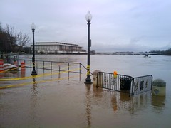
‘Potomac River Floods Washington Harbour’
courtesy of ‘brownpau’
Yesterday, Federal Emergency Management Agency (FEMA) announced , they’d be revising flood maps for Washington, D.C. over the next six months. Per FEMA’s flood map database, the most recent DC flood maps are from 1985, so I’d say DC is in good need of some updating.
The maps help local officials and residents identify known flood risks, and assist in making insurance and development decisions. Maps are updated, per Congressional guidance and direction, to provide communities with solid information on how to mitigate and insure against the risks posed by floods.
DC home and business owners who purchase flood insurance should talk with their local insurance agent to discuss how revised flood maps may affect their options and rates. More information on flood insurance is available at www.floodsmart.gov.