All Politics is Local, Business and Money, Life in the Capital, The Daily Feed, The District

FEMA To Redraw DC Flood Maps

Photo courtesy of
‘Potomac River Floods Washington Harbour’
courtesy of ‘brownpau’

Yesterday, Federal Emergency Management Agency (FEMA) announced , they’d be revising flood maps for Washington, D.C. over the next six months.  Per FEMA’s flood map database, the most recent DC flood maps are from 1985, so I’d say DC is in good need of some updating.

The maps help local officials and residents identify known flood risks, and assist in making insurance and development decisions. Maps are updated, per Congressional guidance and direction, to provide communities with solid information on how to mitigate and insure against the risks posed by floods.

DC home and business owners who purchase flood insurance should talk with their local insurance agent to discuss how revised flood maps may affect their options and rates. More information on flood insurance is available at www.floodsmart.gov.

The Daily Feed

Area Parks Are All Wet

Photo courtesy of
‘Waters rise around Roosevelt Island’
courtesy of ‘snapzdc’

As the flood flows on, more pictures flood in — this time, with news of the parks.

Great Falls and its ever-popular Billy Goat Trail have been closed since Friday. Earlier today, a park official told me the towpath was accessible for a short distance around Old Angler’s Inn, but underwater above and below that point.

In addition to inundating Washington Harbour and the Mt. Vernon Trail, the Potomac has spilled into now-closed Theodore Roosevelt Island and covered parts of the Potomac Heritage Trail as it heads north from the island’s parking lot.

And while there’s the broken lock at the C&O Canal, at mid-afternoon there was just quick-flowing muddy water — and fortunately no houses or pianos or cows floating through. More pics after the break. Continue reading

The Daily Feed

Washington Harbour Boardwalk Flooded

Potomac River Floods Washington Harbour

We’ve got a major Coastal Flood Warning today, with the tidal Potomac swelling to 3-4 ft above flood level, and 5-10 ft around Georgetown. Be safe and cautious if you live or work near the Potomac River or the C&O Canal, and don’t try to drive through flood water. The National Harbour boardwalk and parts of the driveway to K Street are inundated, and as has already been mentioned, a broken C&O Canal lock may cause additional flooding in Lower Georgetown. Parts of the The Mount Vernon Bike Trail are underwater, and of course Old Town Alexandria is getting swamped as well.

After the jump, a hydrograph and some bigger photos. Continue reading

The Daily Feed

C&O Canal Lock Broken Through, Flooding Feared


Photo by palkynebtab

As this morning’s photos and reports indicate, there is some serious flooding going on throughout the DC area.

In Georgetown, the C&O tow path has been closed and buildings and residencies that line the C&O Canal are in peril because an upstream lock has broken through. But according the National Park Service another lock remains in place to hold the water back. Should the second lock fail, then there is a potential for a flood surge along the banks of the historic canal.

Obviously, the main concern is for pedestrian and human safety, but in addition some commercial buildings, such as The Foundry Building, have already started taking flooding precautions by deploying sandbags to their lower level areas.

The Daily Feed, We Green DC

Extra Swampy on Roosevelt Island

Boardwalk on Roosevelt Island

Boardwalk on Roosevelt Island

If you’re a fan of Theodore Roosevelt Island, you know it doesn’t normally look this wet. Ye olde Potomac has flooded in, raising water levels to within about a foot of the boardwalk in places.

Lots of ducks and geese are paddling around on the island, and a flock of seagulls is picking snacks out of the river near the Key Bridge.

I ran through on a late lunch break today, when the tide was rising, and it felt a bit like running on a lake. After a plane passed overhead, I heard that cool swishing, zipping sound of wind high up, above the flooded swamp. It was a cool moment indeed. If you missed ’em earlier, check out our morning flood pics around town, or see more of the island after the break.
Continue reading

The Daily Feed

Flood Warning

Flooded Washington Harbour 2

The Washington Harbour Boardwalk in Georgetown is underwater this morning, as the muddy, debris-strewn Potomac River swells to flood level following Sunday and Monday’s rain. NWS has issued a Coastal Flood Warning for our area. Highest afternoon tides will be around 5:30PM.

The rest of the Harbour is behind a floodwall that they have ready just for these occasions, so those of you who eat at Tony & Joe’s, Agraria, Cabanas, Nick’s Riverside Grill, and Sequioa should be just fine and dry.

After the jump, a video of how fast the river is moving, more photos, and the view from Old Town: Continue reading

The Daily Feed

DCA Under Water, Baggage Claim Flooded

DCA Flooded

UPDATE 12/27: WTOP is reporting that all is back “normal” at DCA this morning. Apparently it took over 100 people working non-stop through the night to get the airport terminal back in working shape. Expect heavy wait times and potentially delays for US Air as they try to play catch up this morning.

UPDATE 6:36 pm: ALL US Airways flights out of DCA for today have been canceled. This is being reported from several people via Twitter. It is also being reported that most flights into DCA may be canceled or at least very delayed.

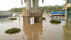
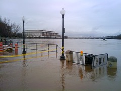
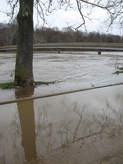
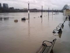
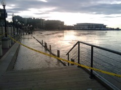
UPDATE 6:00 pm:At least part of DCA is now closed because of this flood. It is being caused by a water main break. There is an amazing video of this below that shows the water pouring down the outside of the baggage claim. Anyone flying into DCA can probably expect some type of delay, especially if flying into C terminal. I’m guessing that A terminal is not really affected by this right now.

I landed at Reagan National Airport just after 3pm today to find the lower level of the C and B terminals, the baggage claim and ground transportation level, quickly being closed off as water poured in from what sounded like multiple sources. At that time, the baggage claim level had a few inches of standing water and rising. There were also very large puddles rapidly forming on the main terminal level as well, just outside the security gate. At this time, we are not sure if the area has been re-opened or if the flood is under control, but either way, I would expect problems and delays if picking someone up at DCA that has checked baggage. Nobody was allowed to go downstairs and no bags were coming out on the belts around 3:20.

If you are at DCA, please let us know of any updates so that we can pass them along to our readers. More pictures and the video after the jump.

Continue reading