History, Mythbusting DC, The Features

DC Mythbusting: Boundary Stones

Photo courtesy of
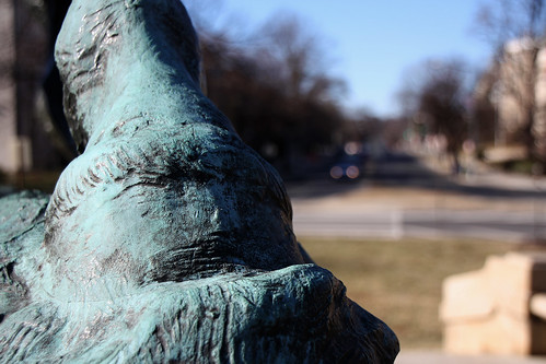
‘Takoma 1791 Boundary Stone’
courtesy of ‘Mr. T in DC’

Welcome to another week’s DC Mythbusting.  This week we’ll talk about a myth I heard when I first moved to DC– that the city’s boundaries are marked off, every mile or so, with stones.  I heard that these stones had been placed long ago when Andrew Ellicott and Benjamin Banneker were surveying the city, and that they’re mostly still there.  I’d never seen them or heard of them outside of that once, so I assumed it was a myth. But I was wrong– this myth is confirmed!

Back in 1791 and 1792, Andrew Ellicott and friends went around the 10-mile square of the planned City of Washington and placed a boundary stone every mile.  The stones had four sides– facing inward towards DC (which read “Jurisdiction of the United States” and a mile number, facing outward (which showed the name of the bordering state, either Maryland or Virginia), and the other sides showed the year the stone was placed and the compass variance at that point.
Continue reading

Mythbusting DC, The Features

DC Mythbusting: Takoma or Takoma Park?

Photo courtesy of

courtesy of ‘Hoffmann’

Welcome to another edition of DC Mythbusting.  This week we’ll be tackling a myth about nomenclature– is the town on the other edge of the boundary with DC called Takoma or Takoma Park?  If it is Takoma Park (which is the name you hear more often), why on earth is the Metro station just called Takoma?

Because there are two different places– Takoma Park is a city in Maryland, while Takoma is a neighborhood in NW Washington DC.  They’re right next to each other, and they used to both be part of a suburb called Takoma Park, until the District of Columbia grew up to its current boundary.  Takoma Park was founded back in 1883 as a Washington garden suburb with “clean air, pure water, and no mosquitoes.”  The area grew as an attractive estate-filled suburb with streetcar service connecting it to Downtown DC.  In 1890 Takoma Park was incorporated as a town by the Maryland General Assembly. However, the northeast boundary line of Washington DC ran right through what was formerly known as Takoma Park. Pierre L’Enfant probably wouldn’t have been too happy with someone messing with the boundaries of his orderly 10-mile square, so the part of the suburb that was within DC remained under District control.

Continue reading

Mythbusting DC, The Features

DC Mythbusting*: Washington Monument On Axis

The Washington Monument is not on axis!

The Washington Monument is not on axis!

 I admit it, I’m definitely a perfectionist.  I’m a big fan of symmetry and straight lines and order.  I think that’s one of the reasons I like DC so much– L’Enfant’s plan is so orderly, with the important sites marked by radiating avenues, and the clear axis of power coming straight down the Mall.  But something has always bothered me– the center of the White House doesn’t look like it lines up with the Washington Monument.  Why, in a city so based on order and symmetry and strong axes, does the Washington Monument not line up?!

Because the ground right at the intersection of the center of the White House and the center of the Capitol was not strong enough to support such a giant structure.  Originally, L’Enfant had proposed a small equestrian statue of George Washingon at the intersection of the east-west axis of the Capitol and the north-south axis of the White House.  But plans changed, and the Washington Monument went there instead.  The Monument was larger and heavier than anything that L’Enfant had envisioned, so it had to be shifted off axis to avoid less solid, marshy ground.  The Monument now rests “about 300 feet southeast of the crossing point of L’Enfant’s two primary vistas” (from Grand Avenues, page 271).  Mystery solved!

So has anyone besides me noticed and been bothered by this?  Or am I the only one who will be sleeping easier tonight knowing that there’s a reason behind the off-axis placement of the Monument?

* Ok, so I realize this isn’t a myth exactly.  But it’s something that’s always bothered me about DC that I couldn’t figure out.  If you have a DC myth in mind that you’d like me to bust/confirm, please e-mail me at shannon (at) welovedc.com.  Thanks!

Essential DC, Mythbusting DC, The District, The Features

DC Mythbusting: Built on a Swamp?

Photo courtesy of
‘Kenilworth Aquatic Gardens – Egret Among the Reeds – 7-20-08’
courtesy of ‘mosley.brian’

Welcome to another edition of DC Mythbusting.  I’m sure you’ve heard that the muggy mosquito-filled summers in DC are due to its location on a swamp.  The Chicago Tribune named their DC bureau’s blog “The Swamp” and it is oh-so-clever to call sleazy politicians “swamp creatures“.  And yes, we all know that summers in the city are humid and gross and miserable… but was DC really built on a swamp?

Not really– today it’d be called more of a tidal plain.  When Pierre L’Enfant set out with a team to survey the city, there was a lot of variety in what he found: fields of tobacco and corn, small forests, and some waterside bluffs and wetlands.  Most of the marshy areas were along the rivers and were susceptible to tidal fluctuations and intermittent flooding, but most of the core of the Federal City wasn’t marshy.  That being said, DC was and still is a water-rich city, with the Rock Creek, the Tiber Creek (which was enclosed in the 1870s), the Potomac River, and the Anacostia River and countless creeks.

Continue reading

Dupont Circle, History, Mythbusting DC, The Features

DC Mythbusting: The DC Streetcar System

Photo courtesy of
‘Washington, DC View east down F Street NW no date’
courtesy of ‘army.arch’

Welcome to another edition of DC Mythbusting.  In order to avoid thinking about the terrible accident on Metro yesterday, I’m going to transport you back in time to when DC had another transit system.  That’s right, our fair city was served by a streetcar system beginning in 1862, and the last of the trains ran a hundred years later in 1962.  Then, as was the trend at the time, the transit system was forced to switch to buses, and the streetcars were no more.  There are many legends about the streetcar– it’s hard to imagine a transit system just leaving town with no marks, but you look around the city today and it’s hard to imagine the thriving streetcar system that existed just a few generations ago.  However, we’re lucky enough to have some very cool remnants of the old streetcar system.

Have you ever walked around Dupont Circle and seen those things that look just like New York City subway entrances?  Well, those are old streetcar entrances.  They were not all fancy like our Metro entrances (no one is standing to the right on escalators here), they’re just simple stairwells down to the streetcar platforms.  Passengers would descend into the station, where the streetcar would run in half-circles.  The Mount Pleasant Line of the streetcar system shut down in 1961, and by 1964 the station entrances were paved over.  But that’s not the end of the story for Dupont’s old streetcar station– in 1995, the station opened as a food court called Dupont Down Under, but apparently people don’t like eating in windowless underground lairs when they could be eating outside in one of DC’s great urban parks.  The project failed within a year, and the area was once again abandoned.  A couple years back, Jim Graham suggested that the space be used for adult clubs; however, neighborhood residents weren’t too excited about that and the space has remained vacant.

Continue reading

History, Mythbusting DC, The District, The Features

DC Mythbusting: “Lobbyist” Coined at Willard Hotel

Photo courtesy of
‘WASHINGTON 2-35’
courtesy of ‘chantoozie’

Welcome to another edition of DC Mythbusting!  This week we’ll be busting the myth of the term ‘lobbyist’.  The legend that I’ve heard countless times in the District is that the term ‘lobbyist’ originated at the Willard Hotel when Ulysses S. Grant was in office (1869-1877).  Apparently President Grant would frequent the Willard Hotel to enjoy brandy and a cigar, and while he was there, he’d be hounded by petitioners asking for legislative favors or jobs.  It is said that President Grant coined the term by referring to the petitioners as “those damn lobbyists.”   The legend has been forwarded by the Washington Post, The Hill, the American Society of News Editors, and, of course, the PR director of the Willard Hotel.

It’s a fun story to tell tourists, and it makes the Willard Hotel even more of a landmark, but the legend is just not true.  Sure, President Grant visited the Willard Hotel and enjoyed his brandy and a cigar, but he did not coin the term ‘lobbyist’.

The verb ‘to lobby’ first appeared in print in the United States in the 1830’s, at least thirty years before Ulysses S. Grant came to Washington.  The term is believed to have originated in British Parliament, and referred to the lobbies outside the chambers where wheeling and dealing took place.  “Lobbyist” was in common usage in Britain in the 1840’s.  Jesse Sheidlower, editor-at-large for the Oxford English Dictionary, believes the term was used as early as 1640 in England to describe the lobbies that were open to constituents to interact with their representatives.

So there you have it: President Grant may have used the term to refer to all those hangers-on at the Willard, but the term was around long before he arrived in DC.

Life in the Capital, Mythbusting DC, The District, The Features

DC Mythbusting: Traffic Circles

Photo courtesy of
‘Sheridan Statue Hoof’
courtesy of ‘Mr. T in DC’

Welcome to another edition of DC Mythbusting!  Last week we discussed how, contrary to popular belief, the height limit wasn’t based on the Capitol or the Washington Monument.  This week I’m here to debunk the myth of the traffic circles in DC.   I have heard from a couple different sources that supposedly Pierre L’Enfant designed the traffic circles in Washington DC as artillery bases to defend the city.  It is said that cannons were placed in the center of the circles to defend against cavalry.  This myth has some traction out there– it can be found in transportation magazines, Washingtonian magazine, and even a book.

The fact is that the circles weren’t even originally envisioned as circles.  According to Grand Avenues: The Story of the French Visionary Who Designed Washington, DC, L’Enfant had planned for squares where the avenues intersected the grid.  In fact, L’Enfant’s plan for the squares was more of an economic development tool: he thought that each square should be settled by residents and Congressmen of a particular state, creating informal state ’embassies’, and that states would then encourage the development of that particular area of the city.  In this way, the squares would encourage both business and residents to locate near their home state square and foster community development.  His plan for the development of the city was to start developing at each of these nodes and connect the nodes with grand avenues. Continue reading

Essential DC, Life in the Capital, Mythbusting DC, The District, The Features

DC Mythbusting: The Height Limit!

Photo courtesy of

‘Cairo Apartment Building’

courtesy of ‘NCinDC’

As an urban planner in DC, I cringe every time I hear a myth about the city (OMG, if I hear the “Pierre L’Enfant hated John Jay” reason for there being no J Streetone more time I’m going to scream).  One of the most widespread myths I hear from out-of-towners and Washingtonians alike is that the height limit in DC states that no building can be taller than the dome of the Capitol, and that the limit was enacted to preserve views of the Capitol and Washington Monument.  This is just plain wrong, and I’m here to tell you why.

Back in 1894, the Cairo apartment building was built on Q Street NW in Dupont Circle.  At 14 stories tall, it was the tallest building in the city at that time, and some residents had concerns about it.  Would it overwhelm the lower-density neighborhood?  Was it structurally sound?  Would existing fire-fighting equipment be able to reach top floors?  Those last two questions were primarily the reason that Congress stepped in in 1899 to establish the Height of Buildings Act.  Technology at the time was advancing quickly, but questions remained about the safety of such a tall building.  Height limits at the time were fairly common in American cities, including Boston and Chicago.

The 1899 Height of Buildings Act established that no building could be taller than the Capitol (289 feet), but if that’s the case, why don’t we have a city full of 28-story buildings?  Well, in 1910 the  act was amended to restrict building heights even further: no building could be more than twenty feet taller than the width of the street that it faces.  So, a building on a street with an 80-foot right-of-way could only be 100 feet, or 10 stories.  This preserved the “light and airy” character of Washington that Thomas Jefferson envisioned.  This 1910 law is still in effect today, and it essentially means that no building can be taller than about 13 stories (with the exception of Pennsylvania Avenue, which is zoned in some places to allow buildings of up to 160 feet). Continue reading