Interviews, Penn Quarter, People, Special Events, The Features

Scribblings: Max Holland

Photo courtesy of cliff1066�
Richard Nixon, Time cover April 30, 1973, “The Watergate Scandal”
courtesy of cliff1066�

On Friday, March 16, join author Max Holland for a look at Mark Felt, the FBI official behind “Deep Throat,” the secretive whistleblower of the Watergate scandal. Holland will be speaking at the International Spy Museum from noon until 2 p.m. on his latest book, Leak: Why Mark Felt Became Deep Throat.

Best known through Hal Holbrook’s portrayal in the film version of Bob Woodward and Carl Bernstein’s All the President’s Men, Felt was regarded for decades as a conscientious but highly secretive whistleblower who shunned the limelight. Yet even after he finally revealed his identity in 2005, questions about his true motivations persisted.

Max Holland has found the missing piece of that Deep Throat puzzle—one that’s been hidden in plain sight all along. He reveals for the first time in detail what truly motivated the FBI’s number-two executive to become the most fabled secret source in American history. In the process, he directly challenges Felt’s own explanations while also demolishing the legend fostered by Woodward and Bernstein’s bestselling account. Continue reading

Downtown, History

National Geographic Museum: The Etruscans – An Italian Civilization


‘Nattional Geographic – Etruscans 01 – 06-09-11’
courtesy of ‘mosley.brian’

I love history. And for me, the older the history, the more I love it. There’s something that fascinates me about seeing how the first people of a given culture tried to figure out the concept of civilization. And for the first couple of millenniums of human history the difference between civilized and true barbarism was incredibly fine. But sadly, DC doesn’t have a large selection of museums that cater to ancient history nerds like me. The Smithsonian’s Natural History Museum has an exhibit which hasn’t been updated since I was in elementary school; and Dumbarton Oaks Museum has a nice collection on the Byzantine Empire, but that is more medieval history than ancient. There isn’t much else without going to another city.

Imagine my excitement to find out that the National Geographic Museum was holding exhibit on the ancient Etruscan Civilization! For the non-history buffs out there, the Etruscan Civilization was an Italian peoples which inhabited roughly the area of modern day Tuscany (which is where we get the name). That area is, roughly speaking, bound by the Tiber River (and Rome) to the south, the Tyrrhenian Sea to the west, and the Apennine Mountains to the north and east. The Etruscans were an important culture in Italy from about 750 BC to around 500 BC, and were an significant influence on Roman culture and history. Continue reading

Downtown, History

National Geographic Museum: Race to the End of the Earth

Photo courtesy of
‘National Geographic – Race Preview – 05-24-11 01’
courtesy of ‘mosley.brian’

What would you do, what would you go through, to be the first explorers to the South Pole? Would you go through months of trekking through -40F degree cold, on a strict ration of food, constantly freezing and wet, and risking death every day? If that sounds like a great time, the National Geographic has the exhibit for you!

To celebrate the 100th anniversary of the first men to reach the South Pole, the National Geographic Museum is hosting an exhibition entitled Race to the End of the Earth. It recounts the challenges of two explorers during their race to reach the South Pole. On a 1,800-mile journey through Antarctica in 1911, explorers Roald Amundsen of Norway and Robert Falcon Scott of Britain fought the elements and raced each other to gain the honor. The exhibit is well suited for the National Geographic, because it adds the adventure and exploration elements to a fascinating and not well known historical story.

Continue reading

Crime & Punishment, History, Life in the Capital, The District, We Love Drinks

Breakin’ the Law: Prohibition in DC

Garrett Peck
Garret Peck (photos by the author)

Wednesday night I attended a talk on Prohibition in DC by local author Garrett Peck. He’s got a new book on the subject, developed as a result of his research for his first book, along with the knowledge he’s amassed leading the Temperance Tour. Much as it is now, DC was a playground for politicians who wanted to try out new rules. Prohibition was thus imposed on the District in 1917 by politicians who, privately (and sometimes publicly) didn’t themselves care much for or about the law.

Continue reading

The Features

Photos: Old Washington in the Winter

Taft Inauguration

Photo courtesy of the DC Public Library

I love Flickr. Here at We Love DC, we all love Flickr. Without your contributions to our pool, the site would be a lot less colorful. But one of my favorite things about Flickr is The Commons, where museums of the world post selections of their historic photography collections. It can be fun sometimes to spend an hour or two lost in a long-ago world, made all the more enlightening because so many of those photos show scenes of our very city: Washington. As we recover from last week’s snowstorm and as we’re currently dealing with another mess of a weather pattern, it seems like the right time to take a look back at how Washingtonians of the past dealt with winter.

Continue reading

The Daily Feed

Historical Facebook Statuses

Historical Facebook Update by Wylo

Although this incredibly entertaining “historical facebook update” is a joke, it definitely once again raises the question, are tweets and Facebook status updates going to one day be considered significant historical artifacts?

Although the Library of Congress is already preparing for this outcome, it remains to be seen whether or not 140 characters of thoughtfulness from the likes of Snoop Doggy Dogg will ever hold as much clout as its counterparts.

Mythbusting DC, The Features

DC Mythbusting: The Lost Forts of DC

Photo courtesy of
‘Fort Gaines at Tenleytown 1864’
courtesy of ‘NCinDC’

Some of the myths about the city seem a little far-fetched, particularly the more historic ones about the layout of the city.  Traffic circles meant to confuse invading armies?  No J Street because Pierre L’Enfant held a grudge?  Come on.  Here’s another one I heard– there’s a system of forts on the outskirts of the District designed to protect the city from an invasion.  This story, like the other two, has to be a myth, right?  The only fort in the city I can think of is Fort Totten, which (as far as I know) is a Metro station and not some Civil War encampment, and I certainly can’t picture an entire ring of forts around the city.  So this myth is pretty easily busted, right?

Not quite. It turns out to be true– there was an incredibly extensive network of forts that once surrounded the city, and today, many of these forts are again being linked together to create a greenway trail for recreational uses. The Fort Circle Park system was a surprise to me, and digging through the history of these parks turned up some other interesting facts.

Continue reading

The Daily Feed

Senate Subway, Then and Now

From historical photoblog Shorpy we get this underground gem:

Senate Subway, 1915

That’s the Senate Subway, c. 1915, just two years after it started operation, part of the whole Capitol Subway System. After the jump, you can see how the Senate Subway still uses open-air cars, though somewhat more modernized.

(Update: Well, boy is my face red; the ‘today’ photo after the jump is actually from the House subway, not Senate. You can tell I’ve never ridden either system, not having had the privilege of working on the Hill myself.) Continue reading

Featured Photo

Feature Photo


‘Boulder Bridge’
courtesy of ‘architeuthis dux’

If you guessed that our photo pool would be filled with snow pictures this week, you were right and deserve a prize. Almost as many pictures as millimeters of snow, and we rounded up some of the best yesterday. That’s not going to stop me choosing another snow picture as our feature photo for the week.

When the first failed attempt to purchase the land that would become Rock Creek Park was introduced in the Senate in 1867, Sen. B. Gratz Brown of Missouri, chairman of the Public Buildings and Grounds committee, said of the proposed park, “it has running water; it has rugged hills; it has picturesque scenery; it has abundance of varied forest timber; it has a native undergrowth blushing with beauty.”

It is this “picturesque scenery” that photographer architeuthis dux found when he wandered past the historic Boulder Bridge. Built in 1902 to carry Beach Drive over the creek, the bridge seems to have been waiting for this snowfall and photo opportunity. The snow, the creek, the quiet serenity, even the slight sepia coloring all combine to create a stunning picture that many won’t believe is inside the heart of our city.
Continue reading

Dupont Circle, History, The Features, Tourism

Mystery Mansion in Dupont: The Heurich House

Photo courtesy of
‘Hidden Bronze Lion’
courtesy of ‘CathyLovesDC’

Tucked away in plain view, the Heurich House is the most intact late-Victorian home in the country. Right in the middle of the action in Dupont Circle – on a corner you have probably walked by at least a dozen times – you are absolutely transported back in time – easily envisioning the family who lived there enjoying a meal in the German beer tavern-styled breakfast room and needle pointing doll clothes and tapestries in the ladies’ retreat room. The furniture, furnishings, wall and ceiling canvas paintings, and even the gas and electric lighting are all original to the house.

The Heurich House museum was home to Christian Heurich, who was regarded as the patriarch of the American brewing industry. After moving to America from Germany in 1872 at the age of 30, he purchased an old, declining brewery and within 10 years, became the largest and most successful brewer in the nation’s capital.

Nicknamed the “Brewmaster’s Castle,” the Heurich House sounds more like a Brickskellar’s with a spiral tower, but the initial disappointment you’ll have to get over first is: they don’t serve any beer. A more fitting nickname for the mansion might be “Fireproof Fortress.” Continue reading

Mythbusting DC, The Features

DC Mythbusting: No J Street Because L’Enfant Held a Grudge

Photo courtesy of
‘DSC_0016.jpg’
courtesy of ‘Chris Rief aka Spodie Odie’

Here at DC Mythbusting we’ve covered a lot of myths, but the one I referenced in the first ever Mythbusting feature is one of the most persistent I’ve ever heard.  That myth attempts to explain the lack of a J Street in DC.  In all four quadrants of our fair city, the street that comes after I Street is K Street.  So what happened to J Street?

The myth states that our city’s planner, Pierre L’Enfant, left out J Street as a slight to John Jay.  Legend has it that L’Enfant hated John Jay for the 1794 Jay Treaty, which settled some issues between America and Great Britain.  The treaty was generally unpopular with Americans because it seemed to greatly favor the British, and the French were mad too because they were an ally during the Revolutionary War and now were fighting Great Britain on their own.  Supposedly, L’Enfant was upset because he was a French-born American, so he was doubly pissed.

However, this myth falls apart entirely when you look at the timeline of things.  L’Enfant’s plan for DC was finalized in early 1792, and the Jay Treaty didn’t happen until 1794.  And the other myth, that John Jay stole Pierre L’Enfant’s wife or girlfriend, also falls apart when you learn that Pierre L’Enfant was gay.  So there’s really no truth about the omission of J Street as a slight to John Jay. Continue reading

Mythbusting DC, The Features

DC Mythbusting: The National Mall as Protest Central

Photo courtesy of
‘Iran Protest in DC’
courtesy of ‘spiggycat’

Welcome to another DC Mythbusting! This week, we’ll be discussing the National Mall and its place as the country’s ‘front yard’ for protesting and gathering.  With such a wide open space, in view of both Congress and the President, clearly the National Mall was created to be a place of protest and free speech, right?  And it has always served the role as the gathering place for Americans with something to say?

Not exactly.  While the Mall was envisioned by Pierre L’Enfant as a “people’s park” along a grand avenue, it has been through many iterations before it became what it is today. The author of Grand Avenues states that the Mall was “a public statement of American destiny,” showing a horizon of possibilities from the Capitol (113).  And while L’Enfant planned a grand vista along the axis (which turned out mostly perfectly) along with a singular equestrian statue, it wasn’t really built like that.
Continue reading

The Daily Feed, The Hill

Video: Capitol Crowds Wave Goodbye to Sen. Kennedy

Here’s some shaky video of Sen. Edward Kennedy’s hearse and procession leaving the Capitol to go down Constitution Ave. to Arlington Cemetery. Hundreds of people lined the lawn and sidewalk, with Kennedy’s staff and colleagues on the Senate steps. As the hearse left the driveway a wave of cheering and applause swept through the crowd, with some waving a final goodbye.

There’s a Flickr group for shots of Kennedy’s funeral.

Continue reading

Essential DC, Mythbusting DC, The District, The Features

DC Mythbusting: Built on a Swamp?

Photo courtesy of
‘Kenilworth Aquatic Gardens – Egret Among the Reeds – 7-20-08’
courtesy of ‘mosley.brian’

Welcome to another edition of DC Mythbusting.  I’m sure you’ve heard that the muggy mosquito-filled summers in DC are due to its location on a swamp.  The Chicago Tribune named their DC bureau’s blog “The Swamp” and it is oh-so-clever to call sleazy politicians “swamp creatures“.  And yes, we all know that summers in the city are humid and gross and miserable… but was DC really built on a swamp?

Not really– today it’d be called more of a tidal plain.  When Pierre L’Enfant set out with a team to survey the city, there was a lot of variety in what he found: fields of tobacco and corn, small forests, and some waterside bluffs and wetlands.  Most of the marshy areas were along the rivers and were susceptible to tidal fluctuations and intermittent flooding, but most of the core of the Federal City wasn’t marshy.  That being said, DC was and still is a water-rich city, with the Rock Creek, the Tiber Creek (which was enclosed in the 1870s), the Potomac River, and the Anacostia River and countless creeks.

Continue reading

The Daily Feed

Street Car at Washington Monument, 1938

Streamliner: 1938

Streamliner: 1938

From Shorpy, the historic photo blog: a DC street car near the Washington Monument in 1938. The view seems to be looking west from 15th St, and could almost be a modern view, aside from the street car, rails, and old-timey automobiles parked on the ramp — right up to the base of the Monument, something you couldn’t do today, what with the ha-ha wall.

Foggy Bottom, History, Monumental, The Features

Monumental: The American Meridian

American Meridian

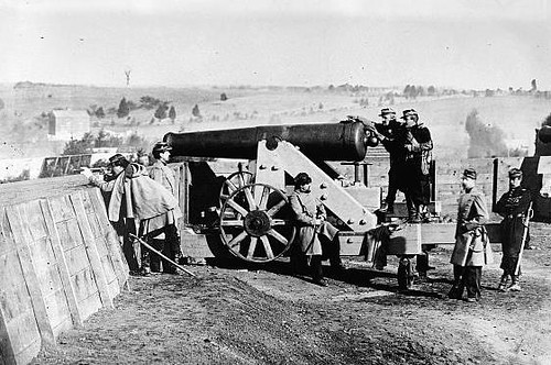
Longitude is probably one of the most important scientific solutions of the modern era. It was easy to work off a set of common star charts and figure out how far north or south of the equator you were. Take a couple readings at sunrise, midday and sunset, chart a few stars, and wham there you are. We’ve been measuring that for millenia now. But Longitude was a lot harder. By the early 18th century, it had become such a problem for sea-faring nations that the King of England set forth a prize to determine the best way of calculating it. Enter John Harrison and his clocks. If you can keep accurate enough time, you can determine your longitude. It took decades of engineering, and the promise of riches (in some cases denied, read Dava Sobel’s Longitude, which is a fascinating historiography of the events surrounding the prize.)

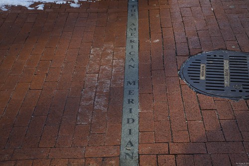
The thing about Longitude that is most interesting is that there’s no clear and obvious choice for a prime meridian, the way there is with latitude and the Equator. Thus, common standards of practice evolved, with prime meridians, and associated maps, appearing at Greenwich, Paris, Rome, and various other European centers. Each set of charts was keyed to use with a specific set of longitudes, with no common standard. Thus it was that Thomas Jefferson set the first American Meridian through the center of the Executive Mansion in 1793. This meridian would stay in place through 1850 when it was moved west 8 blocks to 24th Street at the site of the Naval Observatory (now the grounds of the US Navy Bureau of Medicine and Surgery at 24th and D Streets) where it remained the American line of demarcation and measurement until 1884 when we moved to the Greenwich Standard by International Treaty.

But why have an American Meridian when Greenwich’s would do? The only good way to measure longitude was to take a clock, synchronized from Greenwich’s observatory master clock, and sail it across the Atlantic. Sure, that sounds pretty straight forward, but clocks, even as late as the early 19th century were not anything we’d considerate accurate to the second, not to mention had all kinds of mechanical issues even if you sailed them across the sea. Not to mention the fact that two journeys could come up with two totally different longitudes for the final result. Thus, setting a local point of demarcation allowed for a better continuity of result. Continue reading

History, Special Events, The Daily Feed

Union Station at 100

Union Station: 1921 (via Shorpy)

Today (Sat 4 Oct 2008) marks the 100th anniversary of DC’s Union Station, and also the 20th year since its reopening as a mixed retail and transport hub. Union Station and Amtrak will be celebrating with exhibits, memorabilia, and tours of historic train cars and locomotives.

More from Post’s Get There blog, DCist, and USA Today. Via Rebuilding Place in the Urban Space we get a link to Now Arriving Washington: Union Station and Life in the Nation’s Capital, an extensive dissertation in progress, with a wonderfully voluminous history section.

So be there. Bring cameras.